
This case study considered the impacts of climate change on the Land Capability for Agriculure in Scotland. This used a Land Capability classification system that had been developed using past climate data, then re-implemented using future climate projections.
The Land Capability for Agriculture Classification System was initially developed in the mid-1960s by the Macaulay Institute developed as the Land Use Capability (LUC) system. This was based upon a series of guidelines that allowed soil maps and other landscape and climatic information to be interpreted into land classification maps. In the early 1980s the LUC system was further developed and became the Macaulay Land Capability for Agriculture (LCA) classification. This is now the official agricultural classification system widely used in Scotland by agriculturalists, planners, estate agents and others as a basis of land valuation.
LCA classification is used to rank land on the basis of its potential productivity and cropping flexibility. This is determined by the extent to which the physical characteristics of the land (soil, climate and relief) impose long term restrictions on its use.
The LCA is a seven class system. Four of the classes are further subdivided into divisions. Class 1 represents land that has the highest potential flexibility of use whereas Class 7 land is of very limited agricultural value.
The LCA classification is applied through a series of guidelines that allows a high degree of consistency of classification between users. The classification is based upon a number of assumptions. These specifically include the potential flexibility of cropping and agricultural options, assuming a high level of management. However they exclude other factors, such as distance to market and individual landowner choices, all of which can influence actual land use decisions.
|
Class |
Category |
Climate Limitations |
Land use |
|
Class 1 |
Prime |
None or very minor |
Very wide range of crops with consistently high yields |
|
Class 2 |
Prime |
Minor |
Wide range of crops, except those harvested in winter |
|
Class 3.1 |
Prime |
Moderate |
Moderate range of crops, with good yields for some (cereals and grass) and moderate yields for others (potatoes, field beans, other vegetables) |
|
Class 32 |
Non-Prime |
Moderate |
Moderate range of crops, with average production, but potentially high yields of barley, oats and grass |
|
Class 41 |
Non-Prime |
Moderately-severe |
Narrow range of crops, especially grass due to high yields but harvesting may be restricted |
|
Class 42 |
Non-Prime |
Moderately-severe |
Narrow range of crops, especially grass due to high yields but harvesting may be severely restricted |
|
Class 5 |
Non-Prime |
Severe |
Improved grassland, with mechanical intervention possible to allow seeding, rotavation or ploughing |
|
Class 6 |
Non-Prime |
Very Severe |
Rough grazing pasture only |
|
Class 7 |
Non-Prime |
Extremely Severe |
Very limited agricultural value |
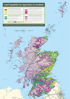
The LCA classes are mapped for the whole of Scotland:
This pilot study considered the implications of climate change on the Land Capability for Agriculture (LCA) system as utilised in Scotland. This involved an analysis of both climate change occurring in recent decades, and projected climate changes into the future. As climate is often one of the key constraints on how land is used, a changing climate can introduce potential new opportunities or risks to particular land-use options. Exploring these issues with a land capability approach emphasises the practical implications of climate change on land-use potential for farmers, managers, planners or other stakeholders through a consideration of the range of options. This can therefore be a key step in planning adaptation responses to climate change.
The objective was to re-map the LCA under future climate scenarios to explore the consequences for land use change, food production and impacts on the wider rural economy.
The LCA and climate projections covers the whole of Scotland.
This study used the 2008 LCA version.
The climatic constraints within LCA are Accumulated Temperature (AT0) and Maximum Potential Soil Moisture Deficit (MPSMD).
AT0 is produced by summing mean daily temperature values above the threshold value of 0°C to provide a monthly aggregate in degree-days for the first six months of the year (January to June inclusive) because of its critical role in leaf growth, and to exclude the potentially detrimental effects of higher temperatures in the latter half of the year. To avoid the possible distorting effects of extreme years on the climatic ‘norm’, the lower quartile AT0 value from the reference time period was used as the parameter value.
The MPSMD parameter reflects the impact on soil moisture levels of the balance between precipitation and evaporation over a year. Typically, soils dry out for a period of time due to the excess of evaporation over precipitation and therefore reach a notional maximum deficit. Evaporative losses are estimated using a potential evapotranspiration (ET0) function, therefore assuming an unlimited supply of water from the soil. This provides a reference value of potential deficit rather than the actual deficit which would often be lower but would also vary with soil conditions.
These two parameters are combined as per the diagram below to identify the climatic classifications for each LCA class. Other approaches identify different types of constraints, i.e. slope, stoniness.

Future LCA climatic constraints were based upon data constructed for the UKCIP02 climate change scenarios (Hulme et al. 2002). These scenarios have been derived from dynamic downscaling of the Hadley Centre global climate model (GCM) HadCM3, through an intermediate atmospheric model and then a 50 km regional climate model (RCM), HadRM3.
References:
Hulme M, Jenkins GJ, Lu X, Turnpenny TR and others (2002) Climate change scenarios for the United Kingdom: the UKCIP02 scientific report. Tyndall Centre for Climate Change Research, School of Environmental Sciences, University of East Anglia, Norwich
The original method for producing the LCA classification was not modified.
This study was conducted by staff at The James Hutton Institute. Please see the accompanying links to papers and reports for details.
Results
Discussion
Our scenario analysis of future land capability has indicated that climate change is likely to substantially modify the current range of options for land-use, and evidence from recent change suggests that this may indeed already be occurring. Regionally, land-use options in the east and south of the country are implied to increase, whilst they remain constrained in most western districts.
The table below shows the area (km2) of each LCA class based upon climate constraints for recent decades and future scenarios, indicating that climate-related ‘prime land’ is projected to more than double in area from 1981-2000 (16741km2) to the 2050s (low scenario: 39239km2; medium-high scenario: 43323km2). This expansion is mainly at the expense of the lower-graded land (classes 5, 6 and 7). Such changes are likely to have a substantial impact on choices made about land use type.
|
Class |
1961-80 |
1981-80 |
2050s (Low) |
2050s (Med-High) |
|
1 |
1675 |
2675 |
20700 |
26450 |
|
2 |
6825 |
8225 |
13850 |
13125 |
|
3.1 |
5600 |
5850 |
4700 |
3750 |
|
3.2 |
5125 |
4225 |
4750 |
4900 |
|
4.1 |
8000 |
8050 |
6875 |
6425 |
|
4.2 |
4075 |
4200 |
3075 |
2675 |
|
5 |
20300 |
18975 |
13525 |
12175 |
|
6 |
21725 |
21100 |
8750 |
7475 |
|
7 |
4625 |
4650 |
1725 |
975 |
The use of other climate scenarios would have provided a range of different LCA responses.