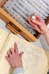
The National Soils Archive is held at the James Hutton Institute in Aberdeen and consists of the following.
- Systematic Soil Survey of Scotland samples
- National Soil Inventory of Scotland (NSIS) 1978-87 and NSIS 2 (2007-10)
- Long term experiments
- New samples that are continually being added
- A soil DNA archive
- 4.8 metric tonnes of soil samples on 2.4km of shelving
- more than 43,000 air-dried soil samples collected from 13,000 locations
- soil samples collected from 1934 to the present day.
The samples stored in the National Soils Archive are a reference to the state of the soils in the past. They are used to test new analyses and to monitor changes in soil over time.
The National Soil Inventory of Scotland is a regular grid of sample locations that were sampled in 1978 – 87 and was re-sampled from 2007-10 to:
- measure any changes in the last 25 years
- test new indicators of soil health
- test UK and EU monitoring methods
- report on the status and stock of organic carbon and nutrients in the soil and their risk from threats such as climate change.
Soil forms in layers called horizons. These are sampled from an inspection pit dug down to 1 metre. Samples are air dried and analysed, then stored here.
Fresh and frozen samples are also taken to extract and analyse DNA to help understand the biology of our soils better.
The sampling locations can be found here.
The field protocols can be downloaded.
The data is used for a wide range of science disciplines and practical applications:
- Soil property status: carbon, nutrients, biodiversity etc. as indicators of soil health
- Research into Greenhouse Gas emissions.
- Land use practices and soil responses to management
- Hydrology, diffuse pollution, erosion
- Soil microbiology
- Long-term monitoring - changes in soil propoerties over time
- Land capability mapping (i.e. the Land Capability for Agriculture)
Scotland’s soils are the foundation of our primary production industries
- An agricultural output of £1.75 billion (2005)
- World records for cereal yields.
- Forest products worth £650 million each year

Scotland’s soils store and filter our water
- Scotland’s soils hold 40 billion litres of water when fully wet which is more than all our fresh water lochs
- Soil acts like a sponge helping to avoid flooding
- Soils also filter water, breaking down the hundreds of different acidifying, toxic contaminants and so protecting out water and food chain

Scotland’s soils store carbon that would otherwise increase global warming
- Scotland is only one third of the UK but contains 54% (3075 Mega tonnes Carbon) of the total UK soil carbon, equivalent to 186 years of our total carbon dioxide emissions
- Much of this carbon is in our peats which are on average 2 metres deep representing 2000 – 4000 years of accumulation
- Our deepest bogs extend to 12 metres = 7 times the height of an average Scot
There are many threats to our soil including climate change, erosion and contamination.
We are also losing soil sealed under buildings and roads. This has been estimated recently as 1200 hectares per year, equivalent to a new town the size of Dunfermline being built each year.
As F.D. Roosevelt, former President of the United States said:“The Nation that destroys its soil, destroys itself”.
The NCIS covers the whole of Scotland. NCIS 1 data was collected on a 5km grid in 1978 – 87 and was re-sampled from 2007-10.
Each period represents a snap-shot of the soils, with re-analysis providing detials of changes between the two periods.
1:250,000 scale Maps of Scotland's soils are available here.

Alternatively, visit the Scotlands Soils pages on the Scottish Governments Scotlands Environment website
The National Soil Inventory of Scotland is a regular grid of sample locations covering the whole of Scotland that were sampled in 1978 – 87 and was re-sampled from 2007-10 to:
- measure any changes in the last 25 years
- test new indicators of soil health
- test UK and EU monitoring methods
- report on the status and stock of organic carbon and nutrients in the soil and their risk from threats such as climate change.
THE NCIS data is held be The James Hutton Institute.
For further information about Soils@Hutton please contact us at soils@hutton.ac.uk.
- SOCiT soil carbon app
The SOCiT iphone app allows users to quickly get a measure of soil organic matter at a site by simply digging a small hole and taking a photograph of the soil with a small colour correction card in shot (cards can be supplied free on request). More information can be found on the SOCiT page.
- Soil Information for Scottish Soils (SIFSS)
The SIFSS iphone app allows a user to find out more about the soil type and some of its properties based on their location. The app covers almost 600 cultivated and uncultivated soil types across Scotland. On the SIFSS webpage you can also query the database based on a postcode, a grid reference, or using the interactive viewer.
- Payments for Ecosystem Services (PES) video
A short animated film produced in collaboration with GRID-Arendal which explains the concept of Payments for Ecosystem Services (PES). - Green Health Project summary video
A short video summarising the main findings of this project about the relationship between green space and human health


